THE TRAIL

Questa History Trail

About the Trail

24 miles north of Taos and 20 miles south of Colorado, on a ridge (“cuesta“) overlooking the Kiowa Trail, one small village holds a visible history of independent devotion, necessary artistry, and rugged determination.

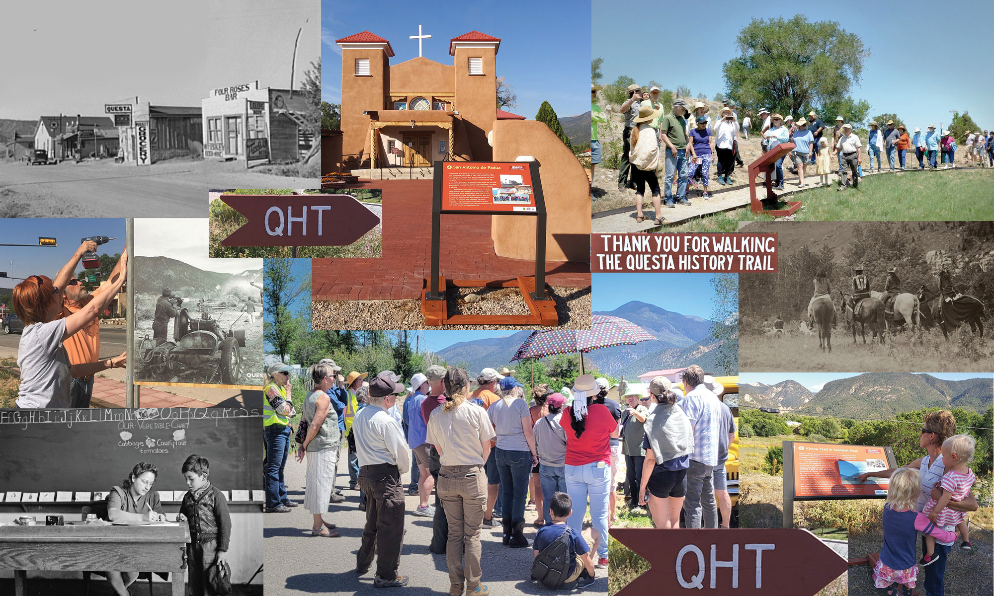
The Questa History Trail is a half-mile walking route that begins at the intersection of state highways 522 and 38, and makes a loop through the historic church plaza and back to your starting point. Start at the triangular Welcome sign and follow the red, wooden arrows.

Interpretive signs weave a vibrant history that reflects many interrelated topics from thousands of years of Native settlements and trade routes, to the impact of the Spanish Inquisition on the American Southwest, rural religious practices, multiculturalism, and the unexpected impact of WWI still very relevant today in Questa.

Short-term parking is available on the corner at the Welcome sign, or just down the hill at the adjacent Visitors Center.

We invite all of you to enjoy this community asset. Whether you are a resident rounding out your own knowledge of where you live, a visitor gaining understanding of this unique area, or a student discovering the many ways that world history, science, culture and heritage inform your life every day, this walk, and this related website can be a revelation. Enjoy!

We look forward to hearing your feedback!

While generally an easy walk, this route is rough in places, and is not all ADA accessible. Almost all of the interpretive signs can be driven to, if necessary.

****Please be respectful of residents and worshipers.****

Photo credits:
Schoolteacher circa 1941, John Collier; Street scene circa 1933, Russell Lee; Indian natives on horseback, Alamy image; Signs and viewers images, Alberta Bouyer; Event photos, yellow truck, Lynn Skall; all other photoss, Carrie Leven.

Signs Along the Questa History Trail

Click on each sign image below to open an expanded view and a deeper look at each topic, with related, thought-provoking content. Follow our .6-mile loop trail to discover Questa’s unfolding story.

Welcome

A diverse team of residents created this trail after input from the community, much study of history and archaeological records, plus local oral history. Here are some facts to orient you. 10,000+ BP Ice Age people roamed the area following migrating herds and seasonal resources. 8,000+ BP Nomadic peoples enjoy the area’s natural resources over thousands of years. Knowing when and where animals moved and plants ripened, hunter-gatherers camped along planned circuits as the seasons changed. 800 AD Ancestors of the Puebloan and Plains people build the earliest adobe pit houses found in this area.

  • 1593 Spanish conquistadors arrive, followed by three centuries of exploration and settlement by Europeans and their descendants.
  • 1805 The Spanish government officially claims this region.
  • 1821 Mexico wins its War of Independence over Spain and Mexico then stretches north into Colorado.
  • 1842 The future village of Questa is founded under the name Rio Colorado del San Antonio.
  • 1846-8 The Mexican-American War results in Mexico ceding the area we now know as New Mexico, and much more.
  • 1853 The United States makes New Mexico a U.S. Territory.
  • 1883 Rio Colorado del San Antonio is renamed Cuesta, meaning ridge or decline in Spanish. The local U.S. Postmaster spells this with a “Q” and the name remains.
  • 1912 New Mexico becomes a U.S. State.

People in this Place

You are standing on what was once Questa’s main road. In the early 1900s, a few stores and at least one hotel sat on the ridge by the plaza you are approaching.

Three centuries of unrest and cultural upheaval had begun with the Spaniards’ arrival in the 1500s. Many frontiersmen, trappers, and traders who followed showed hostility for Native peoples. Comanche, Ute, Jicarilla Apache, and Navajo frequently swept through here, proving a threat to settlers.

A permanent settlement came after the U.S. claimed New Mexico as a territory, established military forts and expanded their “Indian Wars” into this former Spanish, then Mexican land. The names of our founding families reflect Spanish, French, German, and Crypto-Jewish descent. Plus, Native people mixed with settlers, willingly and not, adding to the blend of races and creeds.

Despite the conflicts and isolated landscape, resilient families persevered, marking the beginning of the rural, religious, and rugged Questa lifestyle. Read more about our history, pre-history, and Crypto-Jews at QuestaTrail.org.

Kiowa Trail & Sentinel Peak

Imagine a walled plaza at your back and below you a distant line of riders on horseback. From 5000 years ago and throughout the initial settlement of Questa, a travel way traversed the land between the Rio Grande Gorge and the Sangre de Cristos.

The Kiowa Trail linked the hunting grounds of the grasslands east of the mountains to the trading center of Taos Pueblo. From Taos, the trail’s contour follows the break in slope at ~8600 feet before dropping into Questa, then heading north to Mt. Blanca in Colorado. This passed Ute and Jicarilla Apache villages. The segment used today by Taos Pueblo is called the Red Clay Trail (see sign #7).

Geologic features like Sentinel Peak and Flag Mountain flanking the entrance to Red River Canyon marked the trail’s distance from afar. Historic accounts say settlers at Rio Colorado (Questa) stationed sentries on these high points to warn of approaching danger. Find out more info about this historic travel corridor at QuestaTrail.org.

El Pueblito

The grassy, flat area on the hill opposite you is the site of an early Puebloan village called a pueblito, believed to be built by the same people who settled Taos Pueblo. These were “small villages” with semi-underground pit houses and above ground rooms of adobe, stone, and timber.

Archaeologists think this strategic hilltop and associated trail were used 5000 years ago until the late 1800s. This pueblito may date to 1150 AD. Accounts from the Spaniard Diego De Vargas mention an Apache farming village here in 1694, after the pueblito was abandoned. Other groups known to camp here or in the field below were Ute, Jicarilla Apache, and Kiowa.

According to oral history, the melted adobe ruins were cleared in the early 1930s to make way for the current VFW cemetery, “El Pueblito.” Decades of scavenging have left only a revered final resting place. Read more about this archaeology at QuestaTrail.org.

San Antonio de Padua

Construction of the Iglesia San Antonio de Padua may have begun with the founding of our village in 1842; it was completed by 1860. Over a period of 170 years, there were two restorations and several remodels. Nonetheless, in winter of 2008, the church’s west wall collapsed.

Facing the prospect of demolition, locals formed the non-profit San Antonio del Rio Colorado Historic Preservation group. The Santa Fe Archdiocese turned the church over to them with a deadline of six years.

Many people came together and donated over 49,000 hours of service: they retrofitted a new foundation, made and laid adobe bricks, mudded walls, felled trees to carve new beams and railings, welded metal fixtures, blew glass sconces, and created stained glass windows from historic imagery. The volunteer labor, donations, and prayer succeeded — the church was re-consecrated in August of 2016. Find a full timeline of the church at QuestaTrail.org, with stories recalled on QuestaStories.org.

Acequias: el agua es la vida!

Acequias were a practice brought from Islamic Spain (from the Arabic verb saqá to irrigate). Similar systems were already in use by Natives in the Southwest. These irrigation canals are an example of sharing use, responsibility, and protection of the commons. “Ditches” are filled by water from sources miles away. This Cabresto Ditch is fed from Cabresto Lake, nine miles above our village.

In early spring, the community comes together to clear the ditch of brush and debris, allowing the water an even, controlled flow when the compuertas (headgates) are opened. The mayordomo (ditch boss) parcels out water usage and enforces the schedule for the parciantes (surface water rights owners and users). There is a strong acequia culture along the upper, middle, and lower Rio Grande corridors; these systems have been preserved for over 200 years. Find memories and added info at QuestaStories.org and QuestaTrail.org.

El Oratorio

Across the street at the back of the cemetery is an old adobe structure called an oratorio. Flavio Cisneros, a retired local history teacher, recalls, “I remember my grandmother telling me how a grieving family would hold a wake for the dead at their home, and then they brought the body to the oratorio until it could be buried.”

Flavio’s maternal grandparents passed away during the influenza outbreak of 1918 and are buried in this cemetery.

Questa experienced a hundred years of settlement by very faithful families prior to hosting a resident priest. Like many villages in the rural southwest, the Hermanos Pentientes played an important role in religious ceremonies. Local memories tell us that until the mid-1900s, it was assumed all men in Questa were Hermanos, joining the brotherhood at age 14. Learn about the Penitentes and read more memories at QuestaTrail.org and QuestaStories.org.

Almagre

Between Questa and Red River there are over 20 naturally occurring iron and clay-rich hydrothermal scars. These occur along the mountains’ steepest faces. This scar is locally referred to as Almagre, Spanish for “red ocher,” a mineral pigment. The scars appear yellow from a distance, but pockets of red ocher wash into the river during rainstorms. The water’s reddish hue during these times may have given the Red River its name.

Taos Pueblo people continue their centuries-old tradition of riding horseback through the mountains to Almagre every summer to gather clay and pigment. Questa’s Red Clay Trail segment of the Kiowa Trail took its name from this practice.

Taos Pueblo’s cultural easement allows for a unique use of our public lands and honors the continuation of this tradition. Read more on the Arabic roots of Southwest words, and about this geology at QuestaTrail.org.

Mining

Mining in and around Questa dates back to the 1890s, when gold ore was the goal. World War I created a market for the rare mineral molybdenum: a lighter weight replacement for tungsten used for hardening steel. The first local molybdenum claims were staked in 1914. By the 1950s, fifty tons of ore per day were being extracted through over 50 miles of tunnels in Questa.

The mine became one of the largest private employers in Taos County, however, its change to open-pit mining in 1965 led to deforestation and pollution. Under new ownership by Chevron, the Questa Mine permanently closed in 2014.

It is an EPA Superfund Cleanup Site. Chevron has been instrumental in solar-energy installations that allow our village to now be 100 percent solar powered during daylight hours. Find an in-depth history of the mine at QuestaTrail.org.

Building the Trail

The Trail supports the Questa community’s shift from a mining town to a broader economy, one that focuses on cultural preservation, and includes sharing our local history and surrounding beauty with visitors, residents, and homecoming family.

Our project had its genesis in round table discussions led by Frontier Communities (a small-town category of MainStreet, USA).

The History Trail is one of the founding projects that motivated the creation of the non-profit Questa Creative Council. Our team was much inspired by the work of the St. Anthony’s Church restoration that brought together so many skilled and generous people working toward a valuable goal.

We exist in collaboration with LEAP (Land, Experience, and Art of Place), an educational group under the local non-profit Localogy, that is building a cache for oral histories and archival imagery. The focus is on local stories, many of which reflect the topics introduced on the Questa History Trail. Find these stories online at www.QuestaStories.org. This, in turn, is part of a larger community archive project for Northern New Mexico.

Another related alliance is with the Creative Council’s Northern New Mexico Music project, a platform to do for music what the Questa Stories does for oral history. The upper Rio Grande is home to a remote, isolated, and unique culture that deserves to be honored.

Our founding team is a diverse group of residents.
Mark Sideris – Historic Saint Anthony’s Church Restoration Project foreman, carpenter, and landscape-engineer advisor.
Flavio Cisneros – Retired history teacher and oral-history facilitator.
Jeannie Masters & Kate Cisneros – North Central NM Food Pantry founders and co-directors, and oral-history facilitators.
Tim Long – Small business owner, carpenter, and seasonal ranger at Rio Grande del Norte National Monument.
Alberta Bouyer – Founding Questa Tourism Director, writer, marketing consultant, and project administrator.
Martha Shepp – Artist, editor, and the project’s graphic designer.
With great thanks to Carrie Leven – archaeologist with the Questa Ranger Station.

LEAP* collaborators:
Claire Cote, LEAP director – Artist and educator, gentle instigator, mother, and radical homemaker. Oral history collector and image archive facilitator.
Gaea McGahee, LEAP Creative Associate – Questa Farmers Market founder and manager, adjunct anthropology faculty. Oral history collector and image archive facilitator.

While we lack a self-identified Native American team member, this heritage lives on in the ancestry of many Questa residents and in family stories shared over the generations. Our investigations and research has sought to represent all people within the village’s history in a fair, accurate, and respectful manner. We take pride in the diverse cultures of the southwest and their distinctive features, while seeking the higher truth of a shared humanity.

Photographs: John Collier, Questa student portraits circa 1941, archived at the Library of Congress.
These portraits are from the Library of Congress and we would love to add more, from your collections. Please contact us if you can identify any of these children from 1941 Questa schools, or if you would like to add images of your own.

The Questa History Trail depends on community participation. Join our team and ensure a bright future for this exciting project!

Creation of this project was funded by:
National Park Services’ Rivers, Trails and Conservation Assistance program
Northern Rio Grande National Heritage Area
New Mexico Humanities Council
Support from the Village of Questa
and additional support from the US Forest Service, Chevron, and Taos County Lodgers Tax.

The Questa History Trail is a project of the Questa Creative Council. The QCC is a nonprofit tax-exempt organization under section 501(c)(3) of the US IRS Code.

We thank the QCC’s current sponsors for their support of our ongoing projects:
The Taos Community Foundation, Art Questa, Ambitions Consulting Group, Virsylvia Farms, plus many individual donors.