
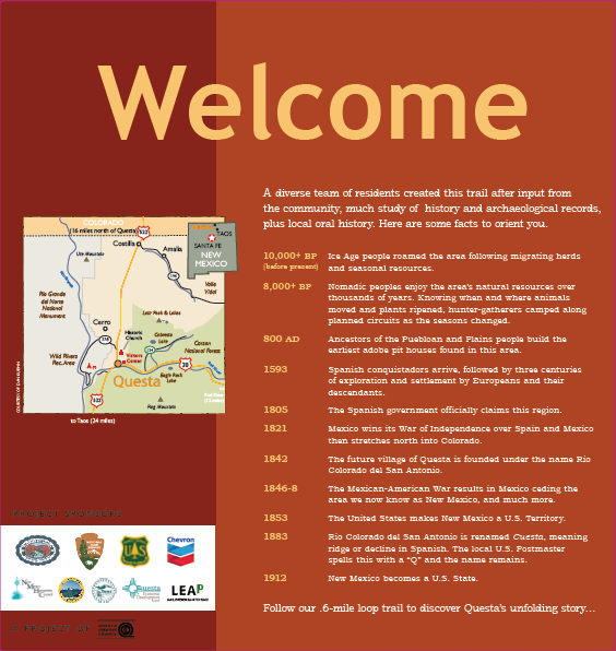
Welcome Sign Text:
A diverse team of residents created this trail after input from the community, much study of history and archaeological records, plus local oral history.
Here are some facts to orient you:
- 10,000+ BP Ice Age people roamed the area following migrating herds and seasonal resources.
- 8,000+ BP Nomadic peoples enjoy the area’s natural resources over thousands of years. Knowing when and where animals moved and plants ripened, hunter-gatherers camped along planned circuits as the seasons changed.
- 800 AD Ancestors of the Puebloan and Plains people build the earliest adobe pit houses found in this area.
- 1593 Spanish conquistadors arrive, followed by three centuries of exploration and settlement by Europeans and their descendants.
- 1805 The Spanish government officially claims this region.
- 1821 Mexico wins its War of Independence over Spain and Mexico then stretches north into Colorado.
- 1842 The future village of Questa is founded under the name Rio Colorado del San Antonio.
- 1846-8 The Mexican-American War results in Mexico ceding the area we now know as New Mexico, and much more.
- 1853 The United States makes New Mexico a U.S. Territory.
- 1883 Rio Colorado del San Antonio is renamed Cuesta, meaning ridge or decline in Spanish. The local U.S. Postmaster spells this with a “Q” and the name remains.
- 1912 New Mexico becomes a U.S. State.
Follow our six-mile loop trail to discover Questa’s unfolding story…
Questa Timeline
Rio Colorado – St. Anthony’s Church and History – Time Line
by Carrie Leven
* Church-related historic events in Bold print
- 1150 – El Pueblito at the mouth of Red River Canyon well-established and settled by people ancestral to Taos Pueblo (current VFW Cemetery)
- 1598 – Spanish colonialization begins in northern New Mexico
- 1694 – visit by Diego de Vargas on the Kiowa trail, report of Apaches living at Rio Colorado
- 1805-1818 – First Questa-area settlers travel to Rio Colorado on Kiowa Trail, aka Taos Trail, Trapper’s Trail and Sangre de Cristo Trail, driving their sheep
- 1808 – 1815 – First water rights
- 1815 – First Questa-area land grant to 50 settlers
- 1818 – First Questa-area baptism records (land grant records?)
- 1821 – Mexico independence from Spain, US trade opened along the Santa Fe & Old Spanish trail; especially from 1830 to 1848, when it was the main trade route, brought many more Americans and Europeans to Questa area
- 1822 – Rio Colorado abandoned due to Indian raids
- 1829 – House built by Don Francisco LaForet near Red River (South Kiowa road)
- 1830 – Don Benito and four other pioneers settle Questa-area
- 1835 – Families come to Questa from Taos to farm and graze sheep in the summers
- 1836 – Canon del Rio Colorado land grant; first church built in Rio Colorado – Oratorio or Capilla at other location
- 1840 – “El Oratorio, a place of prayer and religious congregation, on the outskirts of Questa, by the side of Cabresto Creek, just south of HWY 38, under a cluster of old cottonwood trees stood the old Oratorio, abandoned.”
- 1842 – Petition of 35 families for land grant for San Antonio del Rio Colorado; possession granted by Juan Antonio Martinez in Jan 1842
- 1840s – Rio Colorado buildings constructed on the mesa, rather than down along the river
- 1842 – Rio Colorado officially founded, San Antonio Church begin construction, probably
- 1842 – First baptism records from Rio Colorado
- 1845 – soldiers sent to Rio Colorado due to Cheyenne raiding
- Mid 1840s – late 1850s – construction of Rio Colorado church underway
- 1846 – Mexican – American War; troops to Rio Colorado to protect against raiding
- 1848 – Treaty of Guadalupe de Hildago; land grants upheld, Territorial Period
- 1849 – 100 families living in Questa
- 1851 – New Mexico becomes Territory of the United States; Rio Colorado land grants disputed
- 1851 – US Calvary to Questa to protect settlers from Indian raids
- 1855 – Ponderosa Pine trees harvested on Flag Mountain for roof vigas on San Antonio church, mules used to skid logs down to Questa, some vigas carried by hand by the men
- 1860 – Bishop Lamy visits Rio Colorado and notes “the beautiful new church on the north side of the plaza”
- 1860 – Questa-area land grants not recognized by US Court
- 1873 – New church built in Questa (likely reported in 1873 as part of Rio Grande to Denver Railroad map, and railroad stations connected by stage coach and freight wagon)
- 1880 – St Anthony’s church built, according to Library of Congress (maybe listed as a new church as part of a US Census)
- 1883 – US Post Office established, name change from Rio Colorado to “Questa” meant to be spelled Cuesta – slope, grade, indicating the steep road running to the village built on Cabresto “mesa,” rather than the old settlers’ log cabins found along Cabresto Creek as it joins with the Red River, south of current NM Hwy 38.
- 1899 – Roof renovation of church, names found written on ceiling boards with 1899 date
- 1912 – New Mexico becomes 47th state of United States; Llano Irrigation Company forms
- 1942 – Msgr. Glenn Patrick Smith – first resident parish priest in Questa
- 1943 – single central bell tower at St Anthony Church in old photo
- 1950 – two bell towers at St Anthony’s church shown in old photo
- 1972 – major renovation of church, repair of west walls
- 1999 – Renovation by Cornerstones historic preservation group, bell towers extended
- 2000 – Limestone whitewash over exterior adobe bricks
- 200? – adobe color plaster over lime stone? Must have occurred sometime then?
- 2008 – West wall of St Anthony’s church collapses
- 2009-2010 – many, but not all, parishioners, community members, Village of Questa, want to save church, Priest and Diocese of Santa Fe want to demolish old and build anew
- 2011 – San Antonio church declared a historic building suitable for preservation
- 2011 – Archdiocese relinquishes control of St Anthony’s church to San Antonio del Rio Colorado Preservation for six years to complete restoration
- 2012 – West wall completed
- 2013 – East wall completed
- 2014 – Back / north wall completed, heating system and subfloor
- 2015 – Front portal finished and exterior brown coat, electric system
- 2016 – Plaster coat and paint inside, new floor, sound system, altar screen, retablos, and stained glass windows, installed
- 2016 – August 8, 2016, dedication mass at completed church
- 2017 – Final landscaping and color coat
Repairs to the adobe walls undertaken since the 1970s have neither been lasting nor successful, resulting in continued degradation. An effort in the late 1990s to preserve the original east wall, left the old wall intact but unstable, and hidden and crumbling behind a facade.
Resources:
A majority of the history here comes from, “Another Time in This Place: Historia, Cultura, y Vida en Questa” by Tessie Rael y Ortega and Judith Cuddihy, 2003. This is supplemented with information gathered from Santa Fe Diocese records and land grant maps of Questa-area.